
The Babylonian Mappa Mundi, dating back over 2,600 years, provides a unique insight into the geography and mythological beliefs of the ancient Babylonians.
@Osama Shukir Muhammed Amin FRCP(Glasg) – Wikimedia Commons
The Mappa Mundi, also known as the “Babylonian Map of the World“, is often regarded as the oldest map in existence. While it lacks the scientific precision of modern maps like Google Maps and the artistic grandeur of medieval cartography, it provides a unique insight into how the ancient Babylonians perceived themselves and the world around them.
Discovery and historical context
Created approximately 2,600 to 2,900 years ago, the Mappa Mundi dates back to a time when the Neo-Babylonian Empire was a dominant force in architecture, culture, mathematics, and early scientific studies. Its rediscovery in the 19th century is nearly as intriguing as the artifact itself.
According to the Encyclopedia Britannica, the artifact was unearthed by Hormuzd Rassam, a renowned archaeologist who recovered some of the most valuable Assyrian and Babylonian antiquities ever found, including the tablets containing the Epic of Gilgamesh, the world’s oldest literary text.
The map was discovered in a box during Rassam’s 1881 excavation at Sippar, in present-day Iraq, about 25 miles southwest of Baghdad. However, some believe it may have originally been found in Borsippa, another ancient city located about 70 miles south of Baghdad.
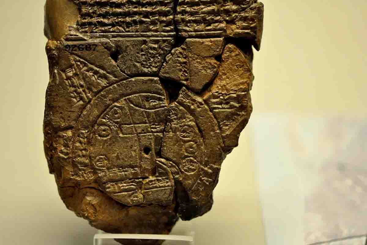
Currently housed in the British Museum in London, the broken tablet measures 4.8 by 3.2 inches (12.19 x 8.13 cm.). It features a circular map and pieces of cuneiform text. Despite its fragmentary state, decades of study have allowed scholars to reconstruct much of its content.
Details of the Babylonian World Map
The map depicts Mesopotamia, often referred to as the “cradle of civilization” because it hosted several important ancient civilizations and cultures, including the Babylonians and Assyrians. The city of Babylon is shown as a rectangular strip near the top of the map, with parallel lines representing the Euphrates River.
This famous river, originating from the northern mountains, flows through Babylon and empties into a marshy area in the south. The map also includes other cities and kingdoms such as Assyria, Der, and Urartu, all encircled by a band representing the “Bitter River” or “Salt Sea,” typically translated as the ocean.
Above the ocean, the map mentions a place “where the Sun is not visible,” possibly considered a land of eternal darkness, akin to places described in the Epic of Gilgamesh. Some text references fantastical creatures inhabiting various regions, such as a winged horse, a great sea serpent, a scorpion-man, and a bull-man, along with more familiar animals like gazelles, panthers, deer, monkeys, ibex, water buffalo, and wolves.
The text also mentions several human figures, including Utnapishtim, the legendary hero who survived the Babylonian flood, and Sargon, the first ruler of the Akkadian Empire. While the Mappa Mundi would be useless for modern navigation in Western Asia, it serves as a valuable historical document, revealing many details about the Neo-Babylonian Empire’s dominance at the time of its creation. As Dr. Irving Finkel, a British Museum expert, explains:
“Babylon is represented as immensely vast compared to other cities on the map,” demonstrating that “the map’s content undoubtedly reflects Babylon as the center of the world.”
Source: Britannica